


Foret de Collobrere/Cabredor/La Grande Pile

Michel DUBOIS
User

Length
13.6 km

Max alt
230 m

Uphill gradient
340 m
Km-Effort
18.2 km

Min alt
32 m

Downhill gradient
347 m
Boucle
Yes
Creation date :
2024-09-23 09:31:32.335
Updated on :
2024-09-23 09:33:28.608
4h07
Difficulty : Medium

FREE GPS app for hiking
 SityTrail
IGN / Geographical institutes
SityTrail Plus
The world is yours!
About
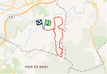
Trail Walking of 13.6 km to be discovered at Provence-Alpes-Côte d'Azur, Var, Les Arcs-sur-Argens. This trail is proposed by Michel DUBOIS.
Description
A FAIRE
Positioning
Country:
France
Region :
Provence-Alpes-Côte d'Azur
Department/Province :
Var
Municipality :
Les Arcs-sur-Argens
Location:
Unknown
Start:(Dec)
Start:(UTM)
298624 ; 4811534 (32T) N.
Comments